Delhi Metro Map 2026, All Lines, Stations, Routes & Interchanges
About Delhi Metro Map
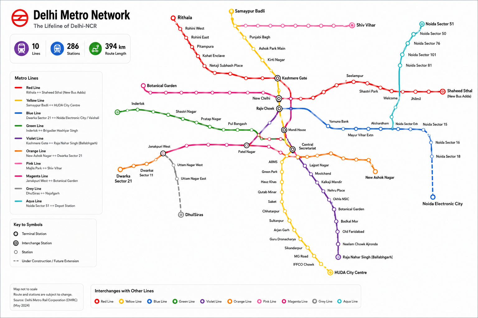
The Delhi Metro Map is a convenient way to understand the extensive metro network connecting Delhi with important parts of the National Capital Region. The network includes multiple colour-coded metro lines covering North, South, East and West Delhi, as well as important destinations in Noida, Ghaziabad, Faridabad, Gurugram and Bahadurgarh.
Use the Delhi Metro route map above to identify metro stations, follow individual lines and locate interchange stations where you can change from one Metro corridor to another. The simplified map is designed to make the network easier to understand without the visual clutter of a traditional station-by-station map.
Delhi Metro currently includes major corridors such as the Red Line, Yellow Line, Blue Line, Green Line, Violet Line, Pink Line, Magenta Line and Grey Line, along with the Airport Express Line. The wider Delhi-NCR metro system also connects with networks such as the Noida Metro Aqua Line and Rapid Metro. DMRC's current operational information lists routes including Shaheed Sthal–Rithala on the Red Line, Samaypur Badli–Millennium City Centre Gurugram on the Yellow Line, Dwarka Sector 21–Noida Electronic City/Vaishali on the Blue Line, Majlis Park–Shiv Vihar on the Pink Line and Janakpuri West–Botanical Garden on the Magenta Line.
Delhi Metro Lines
The Delhi Metro network is divided into different colour-coded lines, with each line serving a different corridor.
Red Line
The Red Line Metro connects Rithala with Shaheed Sthal (New Bus Adda) and provides connectivity across North and North-East Delhi towards Ghaziabad.
Yellow Line
The Yellow Line Metro connects Samaypur Badli with Millennium City Centre Gurugram. It is one of the most important north-south corridors and passes through major interchange locations in central and south Delhi.
Blue Line
The Blue Line Metro connects Dwarka Sector 21 with Noida Electronic City, with a branch from Yamuna Bank to Vaishali. It provides an important east-west connection across Delhi and into Noida and Ghaziabad.
Green Line
The Green Line Metro connects Inderlok/Kirti Nagar with Brigadier Hoshiar Singh in Bahadurgarh, serving parts of West Delhi and the Delhi-Haryana border region.
Violet Line
The Violet Line Metro runs from Kashmere Gate to Raja Nahar Singh (Ballabhgarh), connecting central Delhi with South Delhi and Faridabad.
Pink Line
The Pink Line Metro connects Majlis Park with Shiv Vihar and forms an important orbital-style corridor through several parts of Delhi.
Magenta Line
The Magenta Line Metro runs between Janakpuri West and Botanical Garden, providing an important connection between West Delhi, South Delhi and Noida.
Grey Line
The Grey Line connects Dwarka with Najafgarh and Dhansa Bus Stand, serving areas in South-West Delhi.
Airport Express Line
The Airport Express Line connects New Delhi with Yashobhoomi Dwarka Sector 25, providing a dedicated high-speed connection between central Delhi and Delhi Airport/IGI Airport-side destinations.
Delhi Metro Map with Stations
The map above provides a simplified view of the Delhi Metro stations and routes. Major interchange stations are highlighted so that passengers can quickly identify where they can change between lines.
Some of the most important interchange hubs include:
- Kashmere Gate
- Rajiv Chowk
- New Delhi
- Central Secretariat
- Mandi House
- Yamuna Bank
- Karkarduma
- Welcome
- INA
- Hauz Khas
- Lajpat Nagar
- Rajouri Garden
- Botanical Garden
- Anand Vihar
These stations allow passengers to transfer between different metro corridors and reach a much wider range of destinations.
Delhi Metro Route Map
The Delhi Metro route map can be used to identify the best metro corridor between two locations. First locate your starting station, follow its corresponding coloured line and check the interchange stations available along the route.
If your destination is on another Metro line, change trains at an appropriate interchange station rather than travelling by road.
For example, a passenger travelling between different parts of North Delhi and South Delhi may need to use an interchange depending on the starting and destination stations. The map makes these connections easier to identify visually.
Delhi Metro Interchange Stations
Interchange stations are particularly important when planning a Delhi Metro journey. These stations allow passengers to switch between two or more Metro lines.
Popular interchange stations include Kashmere Gate, Rajiv Chowk, New Delhi, Central Secretariat, Mandi House, Yamuna Bank, INA, Hauz Khas, Lajpat Nagar, Rajouri Garden and Botanical Garden.
The interchange markers on the map make these stations easy to identify.
Delhi Metro Station List
Delhi Metro has hundreds of stations across its extensive network. Instead of presenting every station in one long list, you can browse the network line by line:
- Red Line stations
- Yellow Line stations
- Blue Line stations
- Green Line stations
- Violet Line stations
- Pink Line stations
- Magenta Line stations
- Grey Line stations
- Airport Express stations
This structure is particularly useful for users searching for a specific Delhi Metro station, route or line.
Delhi Metro Route Planner
Looking for a route between two stations?
Use the Delhi Metro network map to:
- Find your starting station.
- Locate your destination station.
- Identify the Metro line serving both stations.
- Check whether you need to change lines.
- Locate the nearest interchange station.
- Follow the connecting line to your destination.
For a website such as MyMetro.in, this section should ideally link directly to your Delhi Metro Route Planner, making the map page the entry point into the route-planning tool.
Delhi Metro Timings
Delhi Metro services operate throughout the day, but first-train and last-train timings vary by line, station and direction. Service frequency can also vary between peak and non-peak periods.
For users planning an early-morning or late-night journey, it is better to check the specific station and route rather than relying on a single network-wide timing.
Delhi Metro Map for Delhi-NCR
The Delhi Metro network extends beyond Delhi into several parts of the NCR. Depending on the line and corridor, passengers can travel towards Noida, Ghaziabad, Faridabad, Gurugram and Bahadurgarh.
The wider network also includes the Noida Metro Aqua Line and Rapid Metro, which provide additional connectivity in the NCR. DMRC's 2024–25 annual report describes its wider O&M network as approximately 394.25 km with 289 stations, including the Aqua Line and Rapid Metro corridors.
Delhi Metro Map 2026
This Delhi Metro Map 2026 is designed as a simplified reference for understanding the current network. Metro routes and station names can change as new corridors and extensions become operational.
DMRC is also expanding the network under Phase IV, with the 2024–25 annual report stating that approximately 110 km across six corridors was under development.
For this reason, the page should be updated whenever a new corridor or extension becomes operational.
Why Use the Delhi Metro?
The Delhi Metro is one of the most convenient ways to travel across Delhi and the surrounding NCR. It connects major residential areas, business districts, educational institutions, shopping destinations, railway stations, transport hubs and important landmarks.
Using the Metro can also help passengers avoid road congestion, particularly during peak commuting hours.
How to use this map
Zoom & pan
Use the zoom controls or scroll to inspect station names and line intersections.
Fullscreen view
Open fullscreen for a distraction-free view on larger screens.
Download & print
Save the high-resolution map or print it for offline reference.
Plan your journey
Use the journey planner in the hero to find the best route between stations.
Frequently asked questions
The Delhi Metro Map is a schematic representation of Delhi's Metro network showing different Metro lines, stations, terminals and interchange points.