Pink Line Metro Route – Map, Stations, Timings & Interchanges
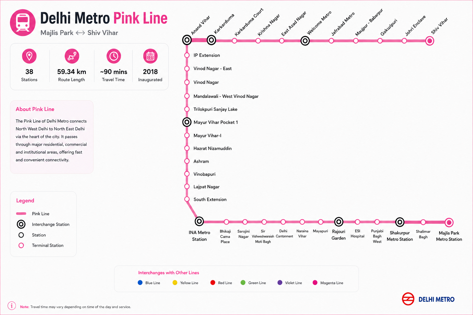
About Pink Line Metro Route
The Pink Line Metro Route is an important corridor of the Delhi Metro network, connecting Majlis Park in North West Delhi with Shiv Vihar in North East Delhi. The route passes through several major residential, commercial and institutional areas, providing convenient connectivity across different parts of Delhi.
The Delhi Metro Pink Line connects important locations such as Majlis Park, Shalimar Bagh, Rajouri Garden, INA, South Extension, Lajpat Nagar, Mayur Vihar, Anand Vihar, Karkarduma, Welcome and Shiv Vihar. With multiple interchange stations along the route, passengers can easily connect to other Delhi Metro lines and reach destinations across the National Capital Region.
Pink Line Metro Route Overview
The Pink Line metro route covers approximately 59 km and has 38 stations. The line operates between Majlis Park and Shiv Vihar, making it an important east-west corridor through Delhi.
- Starting Station: Majlis Park
- Terminal Station: Shiv Vihar
- Total Stations: 38
- Route Length: Approximately 59 km
- Line Colour: Pink
- Major Areas Covered: North West Delhi, Central Delhi, South Delhi, East Delhi and North East Delhi
The route is particularly useful for passengers travelling between North West Delhi, South Delhi, Central Delhi and East Delhi without having to rely entirely on road transport.
Pink Line Metro Stations List
The Pink Line includes the following stations along its route:
Majlis Park, Shalimar Bagh, Shakurpur, Punjabi Bagh West, ESI Hospital, Rajouri Garden, Mayapuri, Naraina Vihar, Delhi Cantonment, Sir Vishweshwaraiah Moti Bagh, Bhikaji Cama Place, Sarojini Nagar, INA, South Extension, Lajpat Nagar, Vinobapuri, Ashram, Hazrat Nizamuddin, Mayur Vihar-I, Mayur Vihar Pocket 1, Trilokpuri Sanjay Lake, Vinod Nagar, Mandawali–West Vinod Nagar, IP Extension, Anand Vihar, Karkarduma, Karkarduma Court, Krishna Nagar, East Azad Nagar, Welcome, Jafrabad, Maujpur–Babarpur, Gokulpuri, Johri Enclave and Shiv Vihar.
For passengers looking for a specific Pink Line metro station, the station map above can be used to identify its position and nearby interchange connections.
Pink Line Metro Interchange Stations
One of the biggest advantages of the Delhi Metro Pink Line is its connectivity with several other metro corridors. Important interchange stations include Rajouri Garden, INA, Lajpat Nagar, Anand Vihar, Karkarduma, Welcome and Majlis Park.
These interchanges make the Pink Line useful for travelling to different parts of Delhi without needing to change to road transport.
Pink Line Metro Timings
The Pink Line Metro generally operates throughout the day, with the first and last train timings varying by station and direction. Train frequency can also change depending on peak hours, weekends and operational conditions.
Passengers should check the latest station-specific timings before travelling, particularly when planning an early-morning or late-night journey.
Why Use the Pink Line Metro?
The Pink Line provides several advantages for daily commuters and visitors travelling across Delhi:
- Connects major residential and commercial areas
- Provides multiple interchange options with other Metro lines
- Connects North West Delhi with East and North East Delhi
- Provides convenient access to important areas such as INA, Lajpat Nagar, Rajouri Garden and Anand Vihar
- Helps reduce dependence on road transport
- Offers a convenient option for daily commuting across Delhi
Plan Your Journey on the Pink Line
Whether you are travelling from Majlis Park to Shiv Vihar, looking for a particular Pink Line metro station, or planning a journey involving an interchange, use the Pink Line Metro Route map above to understand the complete corridor.
You can check the Pink Line metro stations list, interchange stations, route and timings before starting your journey and identify the most convenient station for your destination.
How to use this map
Zoom & pan
Use the zoom controls or scroll to inspect station names and line intersections.
Fullscreen view
Open fullscreen for a distraction-free view on larger screens.
Download & print
Save the high-resolution map or print it for offline reference.
Plan your journey
Use the journey planner in the hero to find the best route between stations.